Jumolhari Trek
(14nighs/15days)
<p class="MsoNormal" style="margin-bottom: 0.0001pt; line-height: 20.9pt; background-image: initial; background-position: initial; background-size: initial; background-repeat: initial; background-attachment: initial; background-origin: initial; background-clip: initial; vertical-align: baseline;"><b><span lang="EN-US" style="font-size:12.0pt;
font-family:"Times New Roman","serif";mso-fareast-font-family:"Times New Roman";
color:#505E29;text-transform:uppercase;border:none windowtext 1.0pt;mso-border-alt:
none windowtext 0in;padding:0in;mso-font-kerning:18.0pt">JOMOLHARI TREK</span></b><b><span lang="EN-US" style="font-size:12.0pt;
font-family:"Times New Roman","serif";mso-fareast-font-family:"Times New Roman";
color:#505E29;text-transform:uppercase;mso-font-kerning:18.0pt"><o:p></o:p></span></b></p><p class="MsoNormal" style="line-height: 14.25pt; background-image: initial; background-position: initial; background-size: initial; background-repeat: initial; background-attachment: initial; background-origin: initial; background-clip: initial; vertical-align: baseline;"><span lang="EN-US" style="font-size:12.0pt;font-family:"Times New Roman","serif";
mso-fareast-font-family:"Times New Roman";color:#4E4E4E;border:none windowtext 1.0pt;
mso-border-alt:none windowtext 0in;padding:0in"> </span></p><p class="MsoNormal" style="line-height: 14.25pt; background-image: initial; background-position: initial; background-size: initial; background-repeat: initial; background-attachment: initial; background-origin: initial; background-clip: initial; vertical-align: baseline;"><span lang="EN-US" style="font-size:12.0pt;font-family:"Times New Roman","serif";
mso-fareast-font-family:"Times New Roman";color:#4E4E4E;border:none windowtext 1.0pt;
mso-border-alt:none windowtext 0in;padding:0in">With altitude differences of
2,500m and nearly 5,000m it offers a wide range of landscapes, fauna and flora.
The highlight of this trek is the spectacular view of Mount Jomolhari from
Jomolhari Basecamp (Jangothang). <b>It
is Nine Days Trek.</b><o:p></o:p></span></p><h4><span lang="EN-US">Day 1: Arrival Paro<i><o:p></o:p></i></span></h4><p><span lang="EN-US" style="color:#2E3417">Pick up from Paro Interational
Airport (2280m) and drop to hotel. If time is available, visit Paro town in the
afternoon.<o:p></o:p></span></p><h4><span lang="EN-US">Day 2: Paro Sightseeing<i><o:p></o:p></i></span></h4><p style="text-align:justify"><!--[if gte vml 1]><v:shapetype id="_x0000_t75"
coordsize="21600,21600" o:spt="75" o:preferrelative="t" path="m@4@5l@4@11@9@11@9@5xe"
filled="f" stroked="f">
<v:stroke joinstyle="miter"/>
<v:formulas>
<v:f eqn="if lineDrawn pixelLineWidth 0"/>
<v:f eqn="sum @0 1 0"/>
<v:f eqn="sum 0 0 @1"/>
<v:f eqn="prod @2 1 2"/>
<v:f eqn="prod @3 21600 pixelWidth"/>
<v:f eqn="prod @3 21600 pixelHeight"/>
<v:f eqn="sum @0 0 1"/>
<v:f eqn="prod @6 1 2"/>
<v:f eqn="prod @7 21600 pixelWidth"/>
<v:f eqn="sum @8 21600 0"/>
<v:f eqn="prod @7 21600 pixelHeight"/>
<v:f eqn="sum @10 21600 0"/>
</v:formulas>
<v:path o:extrusionok="f" gradientshapeok="t" o:connecttype="rect"/>
<o:lock v:ext="edit" aspectratio="t"/>
</v:shapetype><v:shape id="Picture_x0020_5" o:spid="_x0000_s2054" type="#_x0000_t75"
style='position:absolute;left:0;text-align:left;margin-left:1.5pt;
margin-top:38.9pt;width:186.85pt;height:135.15pt;z-index:251659264;
visibility:visible;mso-wrap-style:square;mso-wrap-distance-left:9pt;
mso-wrap-distance-top:0;mso-wrap-distance-right:9pt;
mso-wrap-distance-bottom:0;mso-position-horizontal:absolute;
mso-position-horizontal-relative:text;mso-position-vertical:absolute;
mso-position-vertical-relative:text'>
<v:imagedata src="file:///C:\Users\dell\AppData\Local\Temp\msohtmlclip1\01\clip_image001.jpg"
o:title="paro-dzong-m"/>
<w:wrap type="square"/>
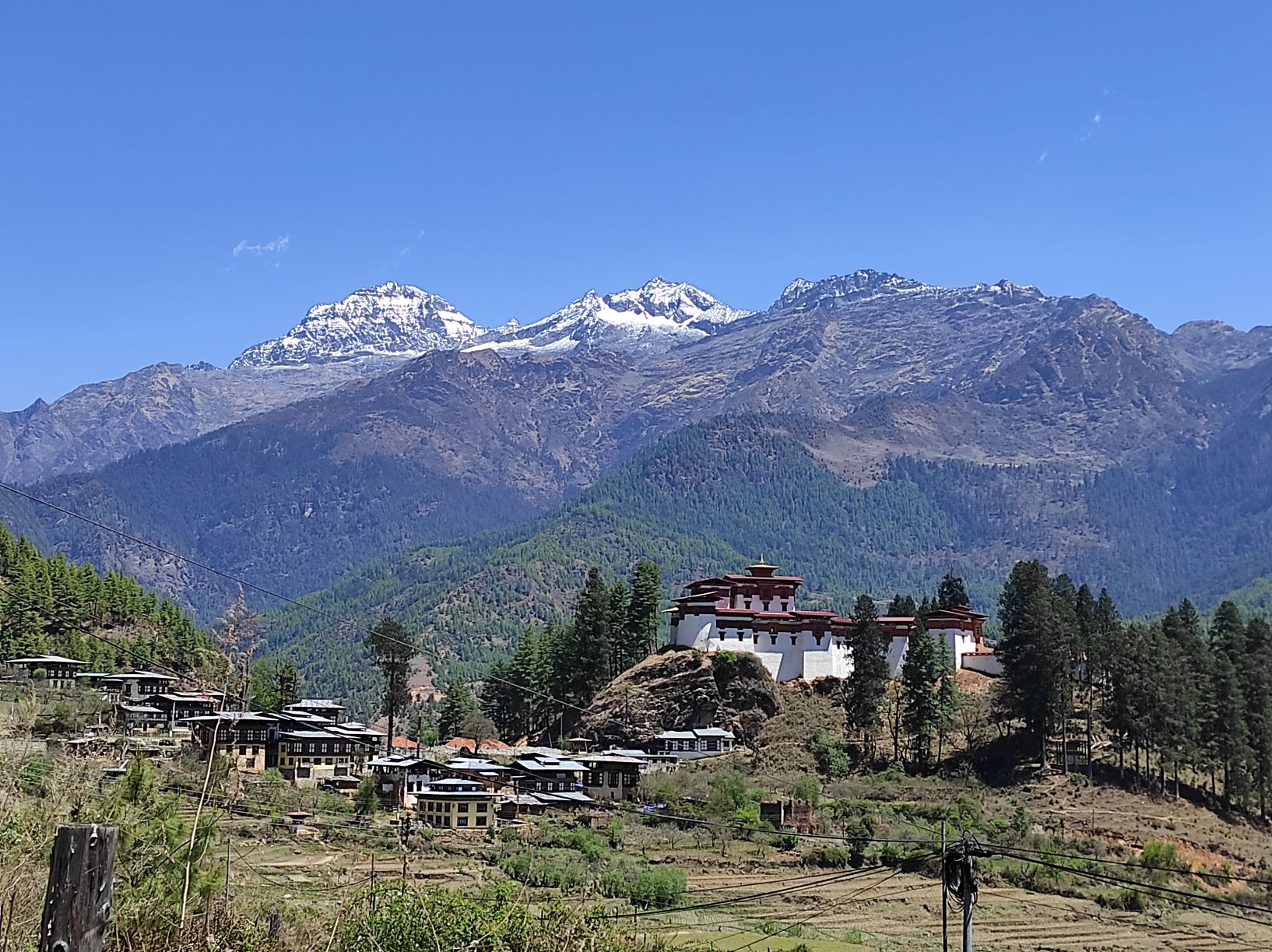
</v:shape><![endif]--><!--[if !vml]--><!--[endif]--><span lang="EN-US" style="color:#2E3417">After breakfast, visit the National Museum housed in the
Ta-Dzong which was built in 1656 and served as the watch tower of Paro Dzong in
the past. Visit Paro Dzong, also called the Rinchen Phug Dzong, which means
fortress on a heap of Jewels. Paro Dzong is one of the most impressive and
well-known dzongs of Bhutan and was built in 1644. After lunch in town, proceed
towards Drukgyel Dzong, 14 kilometres from the Paro town. Also known as the
fortress of victory Drukgyel Dzong was built by Shabdrung Ngawang Namgyal in
1649 to commemorate the victory over Tibetan invaders in 1644. Overnight at
Hotel.<o:p></o:p></span></p><p class="MsoNormal" style="mso-margin-top-alt:auto;mso-margin-bottom-alt:auto;
line-height:normal"><b><span lang="EN-US" style="font-size:12.0pt;font-family:
"Times New Roman","serif";mso-fareast-font-family:"Times New Roman";color:black"> </span></b></p><p class="MsoNormal" style="mso-margin-top-alt:auto;mso-margin-bottom-alt:auto;
line-height:normal"><b><span lang="EN-US" style="font-size:12.0pt;font-family:
"Times New Roman","serif";mso-fareast-font-family:"Times New Roman";color:black">Day
3: Takshang Sightseeing</span></b><span lang="EN-US" style="font-size:12.0pt;
font-family:"Times New Roman","serif";mso-fareast-font-family:"Times New Roman";
color:#2E3417"><o:p></o:p></span></p><p class="MsoNormal" style="mso-margin-top-alt:auto;mso-margin-bottom-alt:auto;
text-align:justify;line-height:normal"><!--[if gte vml 1]><v:shape id="Picture_x0020_1"
o:spid="_x0000_s2053" type="#_x0000_t75" style='position:absolute;left:0;
text-align:left;margin-left:1.5pt;margin-top:10.6pt;width:152.65pt;height:109.65pt;
z-index:251660288;visibility:visible;mso-wrap-style:square;
mso-wrap-distance-left:9pt;mso-wrap-distance-top:0;mso-wrap-distance-right:9pt;
mso-wrap-distance-bottom:0;mso-position-horizontal:absolute;
mso-position-horizontal-relative:text;mso-position-vertical:absolute;
mso-position-vertical-relative:text'>
<v:imagedata src="file:///C:\Users\dell\AppData\Local\Temp\msohtmlclip1\01\clip_image002.jpg"
o:title="tigers-nest-m"/>
<w:wrap type="square"/>
</v:shape><![endif]--><!--[if !vml]--><!--[endif]--><span lang="EN-US" style="font-size:12.0pt;font-family:"Times New Roman","serif";mso-fareast-font-family:
"Times New Roman";color:#2E3417">After breakfast, drive for about eight
kilometres north of Paro town to visit Bhutan's most well known monastery,
Taktshang or Tiger's Lair perched on a cliff 900 metres above the valley floor.
Legend has it that Guru Rinpoche, who brought Buddhism to Bhutan in the eighth
century flew to Taktshang on a tigress and mediated for three months. The trek
to the monastery and back takes about four hours. Lunch will be served in the
cafeteria near the monastery. Afternoon prepare for the Jomolhari Trek.</span><span lang="EN-US" style="font-size:12.0pt;font-family:"Times New Roman","serif";
mso-fareast-font-family:"Times New Roman";color:#4E4E4E"><o:p></o:p></span></p><table class="MsoNormalTable" border="0" cellspacing="0" cellpadding="0" width="90%" style="width: 90%;">
<tbody><tr>
<td valign="top" style="padding:0in 0in 0in 0in">
<p class="MsoNormal" style="margin-bottom:0in;margin-bottom:.0001pt;line-height:
normal"><b><span lang="EN-US" style="font-size:12.0pt;font-family:"Times New Roman","serif";
mso-fareast-font-family:"Times New Roman";border:none windowtext 1.0pt;
mso-border-alt:none windowtext 0in;padding:0in"> </span></b></p>
<p class="MsoNormal" style="margin-bottom:0in;margin-bottom:.0001pt;line-height:
normal"><b><span lang="EN-US" style="font-size:12.0pt;font-family:"Times New Roman","serif";
mso-fareast-font-family:"Times New Roman";border:none windowtext 1.0pt;
mso-border-alt:none windowtext 0in;padding:0in">Day 4: Paro-Gunitsawa Village
– Sharna Zampa</span></b><span lang="EN-US" style="font-size:12.0pt;font-family:
"Times New Roman","serif";mso-fareast-font-family:"Times New Roman""><br>
<!--[if !supportLineBreakNewLine]--><br>
<!--[endif]--><o:p></o:p></span></p>
<p class="MsoNormal" style="margin-bottom:10.2pt;line-height:normal;vertical-align:
baseline"><span lang="EN-US" style="font-size:12.0pt;font-family:"Times New Roman","serif";
mso-fareast-font-family:"Times New Roman"">40mins, 80 m descent, camp
altitude 2,850 m.<o:p></o:p></span></p>
<p class="MsoNormal" style="margin-bottom:10.2pt;text-align:justify;line-height:
normal;vertical-align:baseline"><span lang="EN-US" style="font-size:12.0pt;
font-family:"Times New Roman","serif";mso-fareast-font-family:"Times New Roman"">Drive
from Paro to Gunitsawa. This trek begins at Gunitsawa Village where you
pass the army post. The campsite is on the opposite side of the river,
not far from Gunitsawa.<o:p></o:p></span></p>
</td>
</tr>
</tbody></table><p class="MsoNormal" style="margin-bottom: 0.0001pt; line-height: 14.25pt; background-image: initial; background-position: initial; background-size: initial; background-repeat: initial; background-attachment: initial; background-origin: initial; background-clip: initial; vertical-align: baseline;"><span lang="EN-US" style="font-size:12.0pt;font-family:"Times New Roman","serif";mso-fareast-font-family:
"Times New Roman";color:#4E4E4E"> </span></p><table class="MsoNormalTable" border="0" cellspacing="0" cellpadding="0" width="90%" style="width: 90%;">
<tbody><tr>
<td valign="top" style="padding:0in 0in 0in 0in">
<p class="MsoNormal" style="margin-bottom:0in;margin-bottom:.0001pt;line-height:
normal"><br></p>
<p class="MsoNormal" style="margin-bottom:0in;margin-bottom:.0001pt;line-height:
normal"><b><span lang="EN-US" style="font-size:12.0pt;font-family:"Times New Roman","serif";
mso-fareast-font-family:"Times New Roman";border:none windowtext 1.0pt;
mso-border-alt:none windowtext 0in;padding:0in"> </span></b></p>
<p class="MsoNormal" style="margin-bottom:0in;margin-bottom:.0001pt;line-height:
normal"><b><span lang="EN-US" style="font-size:12.0pt;font-family:"Times New Roman","serif";
mso-fareast-font-family:"Times New Roman";border:none windowtext 1.0pt;
mso-border-alt:none windowtext 0in;padding:0in">Day 5: Sharna Zampa -
Thangthangkha</span></b><span lang="EN-US" style="font-size:12.0pt;font-family:
"Times New Roman","serif";mso-fareast-font-family:"Times New Roman""><br>
<!--[if !supportLineBreakNewLine]--><br>
<!--[endif]--><o:p></o:p></span></p>
<p class="MsoNormal" style="margin-bottom:10.2pt;line-height:normal;vertical-align:
baseline"><span lang="EN-US" style="font-size:12.0pt;font-family:"Times New Roman","serif";
mso-fareast-font-family:"Times New Roman"">Distance 22 km, 7-8 hours,
770 m ascent, 10 m descent, camp altitude 3,610 m.<o:p></o:p></span></p>
<p class="MsoNormal" style="margin-bottom:10.2pt;text-align:justify;line-height:
normal;vertical-align:baseline"><span lang="EN-US" style="font-size:12.0pt;
font-family:"Times New Roman","serif";mso-fareast-font-family:"Times New Roman"">On
this long day, the trail continues with lots of small ups and downs. After
going uphill through the river valley the valley finally narrows gradually to
a mere path which descends to a meadow where a camp will be set up. From
here, if weather permits, you will have the first great view of Mt.
Jomolhari.<o:p></o:p></span></p>
</td>
</tr>
</tbody></table><p class="MsoNormal" style="margin-bottom: 0.0001pt; line-height: 14.25pt; background-image: initial; background-position: initial; background-size: initial; background-repeat: initial; background-attachment: initial; background-origin: initial; background-clip: initial; vertical-align: baseline;"><span lang="EN-US" style="font-size:12.0pt;font-family:"Times New Roman","serif";mso-fareast-font-family:
"Times New Roman";color:#4E4E4E"> </span></p><table class="MsoNormalTable" border="0" cellspacing="0" cellpadding="0" width="90%" style="width: 90.96%; margin-left: -4.5pt;">
<tbody><tr>
<td width="100%" valign="top" style="width:100.0%;padding:0in 0in 0in 0in">
<p class="MsoNormal" style="margin-bottom:0in;margin-bottom:.0001pt;line-height:
normal"><b><span lang="EN-US" style="font-size:12.0pt;font-family:"Times New Roman","serif";
mso-fareast-font-family:"Times New Roman";border:none windowtext 1.0pt;
mso-border-alt:none windowtext 0in;padding:0in">Day 6: Thangthangkha –
Jangothang</span></b><span lang="EN-US" style="font-size:12.0pt;font-family:
"Times New Roman","serif";mso-fareast-font-family:"Times New Roman""><br>
<!--[if !supportLineBreakNewLine]--><br>
<!--[endif]--><o:p></o:p></span></p>
<p class="MsoNormal" style="margin-bottom:10.2pt;line-height:normal;vertical-align:
baseline"><span lang="EN-US" style="font-size:12.0pt;font-family:"Times New Roman","serif";
mso-fareast-font-family:"Times New Roman"">Distance 19 km, 5-6 hours, 480 m
ascent, camp altitude 4,080 m.<o:p></o:p></span></p>
<p class="MsoNormal" style="margin-bottom:10.2pt;text-align:justify;line-height:
normal;vertical-align:baseline"><span lang="EN-US" style="font-size:12.0pt;
font-family:"Times New Roman","serif";mso-fareast-font-family:"Times New Roman"">If
you did not see Mt. Jomolhari the previous evening, you will still have a
chance to get a great view early this morning. This morning the trek
continues up the Paro Chhu valley which widens into patches of alpine meadow
and scanty growths of forest. You will cross an army checkpoint along the way
and enjoy a spectacular view of high mountain ridges and snow-capped peaks.
In this area yaks and their herder’s homes become a regular feature of the
landscape. Passing the villages Soe, Takethang and Dangochang is another
asset on this day. After reaching Jangothang, one of the most beautiful
campsites of the Himalayas, you will again have a spectacular view of Mount
Jomolhari.<o:p></o:p></span></p>
</td>
</tr>
</tbody></table><p class="MsoNormal" style="margin-bottom: 0.0001pt; line-height: 14.25pt; background-image: initial; background-position: initial; background-size: initial; background-repeat: initial; background-attachment: initial; background-origin: initial; background-clip: initial; vertical-align: baseline;"><span lang="EN-US" style="font-size:12.0pt;font-family:"Times New Roman","serif";mso-fareast-font-family:
"Times New Roman";color:#4E4E4E"> </span></p><table class="MsoNormalTable" border="0" cellspacing="0" cellpadding="0" width="90%" style="width: 90%;">
<tbody><tr>
<td valign="top" style="padding:0in 0in 0in 0in">
<p class="MsoNormal" style="margin-bottom:0in;margin-bottom:.0001pt;line-height:
normal"><b><span lang="EN-US" style="font-size:12.0pt;font-family:"Times New Roman","serif";
mso-fareast-font-family:"Times New Roman";border:none windowtext 1.0pt;
mso-border-alt:none windowtext 0in;padding:0in">Day 7: Jangothang Halt</span></b><span lang="EN-US" style="font-size:12.0pt;font-family:"Times New Roman","serif";
mso-fareast-font-family:"Times New Roman""><br>
<!--[if !supportLineBreakNewLine]--><br>
<!--[endif]--><o:p></o:p></span></p>
<p class="MsoNormal" style="margin-bottom:10.2pt;text-align:justify;line-height:
normal;vertical-align:baseline"><span lang="EN-US" style="font-size:12.0pt;
font-family:"Times New Roman","serif";mso-fareast-font-family:"Times New Roman"">The
rest day in Jangothang provides plenty of possibilities for day hikes with
great views of lakes and snow capped mountains such as Jomolhari and Jichu
Drake. There are good chances to spot some blue sheep on the upper slopes of
the valley. Jangothang is a perfect environment for your acclimatization. You
can also trek up to Tosoh or hike around the area. There are good short
hiking trails in three directions. Jomolhari and its subsidiary mountain
chains lie directly west, Jichu Drake to the north and there are a number of
unclimbed peaks to the east.<o:p></o:p></span></p>
</td>
</tr>
</tbody></table><p class="MsoNormal" style="margin-bottom: 0.0001pt; line-height: 14.25pt; background-image: initial; background-position: initial; background-size: initial; background-repeat: initial; background-attachment: initial; background-origin: initial; background-clip: initial; vertical-align: baseline;"><span lang="EN-US" style="font-size:12.0pt;font-family:"Times New Roman","serif";mso-fareast-font-family:
"Times New Roman";color:#4E4E4E"> </span></p><table class="MsoNormalTable" border="0" cellspacing="0" cellpadding="0" width="90%" style="width: 90%;">
<tbody><tr>
<td valign="top" style="padding:0in 0in 0in 0in">
<p class="MsoNormal" style="margin-bottom:0in;margin-bottom:.0001pt;line-height:
normal"><b><span lang="EN-US" style="font-size:12.0pt;font-family:"Times New Roman","serif";
mso-fareast-font-family:"Times New Roman";border:none windowtext 1.0pt;
mso-border-alt:none windowtext 0in;padding:0in"> </span></b></p>
<p class="MsoNormal" style="margin-bottom:0in;margin-bottom:.0001pt;line-height:
normal"><b><span lang="EN-US" style="font-size:12.0pt;font-family:"Times New Roman","serif";
mso-fareast-font-family:"Times New Roman";border:none windowtext 1.0pt;
mso-border-alt:none windowtext 0in;padding:0in">Day 8: Jangothang – Lingshi</span></b><span lang="EN-US" style="font-size:12.0pt;font-family:"Times New Roman","serif";
mso-fareast-font-family:"Times New Roman""><br>
<!--[if !supportLineBreakNewLine]--><br>
<!--[endif]--><o:p></o:p></span></p>
<p class="MsoNormal" style="margin-bottom:10.2pt;text-align:justify;line-height:
normal;vertical-align:baseline"><span lang="EN-US" style="font-size:12.0pt;
font-family:"Times New Roman","serif";mso-fareast-font-family:"Times New Roman"">Distance
16km, six to seven hours, 810m ascent, 1,090m descent, camp altitude 3,800m.<o:p></o:p></span></p>
<p class="MsoNormal" style="margin-bottom:10.2pt;text-align:justify;line-height:
normal;vertical-align:baseline"><span lang="EN-US" style="font-size:12.0pt;
font-family:"Times New Roman","serif";mso-fareast-font-family:"Times New Roman"">The
trail leads to a last settlement in the valley and drops to the Paro Chhu.
Passing the lake of Tshophu (4,380m) you will climb up steeply to Bhonte La
pass at 4,890 m, the highest point of this trek route. Reaching the Dhumzo
Chhu river, you trek downstream passing the few houses of Soi Yaktsa (Dhumzo)
to arrive at your camp soon after.<o:p></o:p></span></p>
</td>
</tr>
</tbody></table><p class="MsoNormal" style="margin-bottom: 0.0001pt; line-height: 14.25pt; background-image: initial; background-position: initial; background-size: initial; background-repeat: initial; background-attachment: initial; background-origin: initial; background-clip: initial; vertical-align: baseline;"><span lang="EN-US" style="font-size:12.0pt;font-family:"Times New Roman","serif";mso-fareast-font-family:
"Times New Roman";color:#4E4E4E"> </span></p><table class="MsoNormalTable" border="0" cellspacing="0" cellpadding="0" width="90%" style="width: 90%;">
<tbody><tr>
<td valign="top" style="padding:0in 0in 0in 0in">
<p class="MsoNormal" style="margin-bottom:0in;margin-bottom:.0001pt;line-height:
normal"><b><span lang="EN-US" style="font-size:12.0pt;font-family:"Times New Roman","serif";
mso-fareast-font-family:"Times New Roman";border:none windowtext 1.0pt;
mso-border-alt:none windowtext 0in;padding:0in"> </span></b><br></p>
<p class="MsoNormal" style="margin-bottom:0in;margin-bottom:.0001pt;line-height:
normal"><b><span lang="EN-US" style="font-size:12.0pt;font-family:"Times New Roman","serif";
mso-fareast-font-family:"Times New Roman";border:none windowtext 1.0pt;
mso-border-alt:none windowtext 0in;padding:0in">Day 9: Lingshi – Shodu</span></b><span lang="EN-US" style="font-size:12.0pt;font-family:"Times New Roman","serif";
mso-fareast-font-family:"Times New Roman""><br>
<!--[if !supportLineBreakNewLine]--><br>
<!--[endif]--><o:p></o:p></span></p>
<p class="MsoNormal" style="margin-bottom:0in;margin-bottom:.0001pt;text-align:
justify;line-height:normal;vertical-align:baseline"><span lang="EN-US" style="font-size:12.0pt;font-family:"Times New Roman","serif";mso-fareast-font-family:
"Times New Roman";color:#333333;border:none windowtext 1.0pt;mso-border-alt:
none windowtext 0in;padding:0in">Distance 22km, eight to nine hours, 940m
ascent, 920m descent, camp altitude 4,080m.</span><span lang="EN-US" style="font-size:12.0pt;font-family:"Times New Roman","serif";mso-fareast-font-family:
"Times New Roman""> <o:p></o:p></span></p>
<p class="MsoNormal" style="margin-bottom:0in;margin-bottom:.0001pt;text-align:
justify;line-height:normal;vertical-align:baseline"><span lang="EN-US" style="font-size:12.0pt;font-family:"Times New Roman","serif";mso-fareast-font-family:
"Times New Roman""> </span></p>
<p class="MsoNormal" style="margin-bottom:0in;margin-bottom:.0001pt;text-align:
justify;line-height:normal;vertical-align:baseline"><span lang="EN-US" style="font-size:12.0pt;font-family:"Times New Roman","serif";mso-fareast-font-family:
"Times New Roman";color:#333333;border:none windowtext 1.0pt;mso-border-alt:
none windowtext 0in;padding:0in">The trail climbs up to the Yelila pass at an
altitude of 4,930m. From the pass, on a clear day you will get an excellent
view of Jumolhari, Tserimgang and Masanggang. The trek from the pass to the
campsite at Shodu is a steep downhill.</span><span lang="EN-US" style="font-size:12.0pt;font-family:"Times New Roman","serif";mso-fareast-font-family:
"Times New Roman""><o:p></o:p></span></p>
</td>
</tr>
<tr>
<td valign="top" style="padding:0in 0in 0in 0in">
<p class="MsoNormal" style="margin-bottom:0in;margin-bottom:.0001pt;line-height:
normal"><b><span lang="EN-US" style="font-size:12.0pt;font-family:"Times New Roman","serif";
mso-fareast-font-family:"Times New Roman";border:none windowtext 1.0pt;
mso-border-alt:none windowtext 0in;padding:0in"> </span></b></p>
<p class="MsoNormal" style="margin-bottom:0in;margin-bottom:.0001pt;line-height:
normal"><b><span lang="EN-US" style="font-size:12.0pt;font-family:"Times New Roman","serif";
mso-fareast-font-family:"Times New Roman";border:none windowtext 1.0pt;
mso-border-alt:none windowtext 0in;padding:0in">Day 10: Shodu – Barshong</span></b><b><span lang="EN-US" style="font-size:12.0pt;font-family:"Times New Roman","serif";
mso-fareast-font-family:"Times New Roman""> </span></b><span lang="EN-US" style="font-size:12.0pt;font-family:"Times New Roman","serif";mso-fareast-font-family:
"Times New Roman""><br>
<!--[if !supportLineBreakNewLine]--><br>
<!--[endif]--><o:p></o:p></span></p>
<p class="MsoNormal" style="margin-bottom:0in;margin-bottom:.0001pt;text-align:
justify;line-height:normal;vertical-align:baseline"><span lang="EN-US" style="font-size:12.0pt;font-family:"Times New Roman","serif";mso-fareast-font-family:
"Times New Roman";color:#333333;border:none windowtext 1.0pt;mso-border-alt:
none windowtext 0in;padding:0in">Distance 16km, five to six hours, 250m
ascent, 670m descent, camp altitude 3,710m.</span><span lang="EN-US" style="font-size:12.0pt;font-family:"Times New Roman","serif";mso-fareast-font-family:
"Times New Roman""> <o:p></o:p></span></p>
<p class="MsoNormal" style="margin-bottom:0in;margin-bottom:.0001pt;text-align:
justify;line-height:normal;vertical-align:baseline"><span lang="EN-US" style="font-size:12.0pt;font-family:"Times New Roman","serif";mso-fareast-font-family:
"Times New Roman""> </span></p>
<p class="MsoNormal" style="margin-bottom:0in;margin-bottom:.0001pt;text-align:
justify;line-height:normal;vertical-align:baseline"><span lang="EN-US" style="font-size:12.0pt;font-family:"Times New Roman","serif";mso-fareast-font-family:
"Times New Roman";color:#333333;border:none windowtext 1.0pt;mso-border-alt:
none windowtext 0in;padding:0in">The trail follows the Thimphu Chhu through
rhododendron forests, past beautiful waterfalls along the way. The valley
narrows till the path takes to the slopes and gradually ascends to the ruins of
Barshong Dzong.</span><span lang="EN-US" style="font-size:12.0pt;font-family:
"Times New Roman","serif";mso-fareast-font-family:"Times New Roman""><o:p></o:p></span></p>
</td>
</tr>
</tbody></table><p class="MsoNormal" style="margin-bottom: 0.0001pt; line-height: 14.25pt; background-image: initial; background-position: initial; background-size: initial; background-repeat: initial; background-attachment: initial; background-origin: initial; background-clip: initial; vertical-align: baseline;"><span lang="EN-US" style="font-size:12.0pt;font-family:"Times New Roman","serif";mso-fareast-font-family:
"Times New Roman";color:#4E4E4E"> </span></p><table class="MsoNormalTable" border="0" cellspacing="0" cellpadding="0" width="90%" style="width: 90%;">
<tbody><tr>
<td valign="top" style="padding:0in 0in 0in 0in">
<p class="MsoNormal" style="margin-bottom:0in;margin-bottom:.0001pt;line-height:
normal"><b><span lang="EN-US" style="font-size:12.0pt;font-family:"Times New Roman","serif";
mso-fareast-font-family:"Times New Roman";border:none windowtext 1.0pt;
mso-border-alt:none windowtext 0in;padding:0in">Day 11: Barshong – Dolam
Kencho</span></b><span lang="EN-US" style="font-size:12.0pt;font-family:"Times New Roman","serif";
mso-fareast-font-family:"Times New Roman""><br>
<!--[if !supportLineBreakNewLine]--><br>
<!--[endif]--><o:p></o:p></span></p>
<p class="MsoNormal" style="margin-bottom:10.2pt;line-height:normal;vertical-align:
baseline"><span lang="EN-US" style="font-size:12.0pt;font-family:"Times New Roman","serif";
mso-fareast-font-family:"Times New Roman"">Distance 15km, four to six hours,
290m ascent, 640m descent, camp altitude 3,320m.<o:p></o:p></span></p>
<p class="MsoNormal" style="margin-bottom:10.2pt;line-height:normal;vertical-align:
baseline"><span lang="EN-US" style="font-size:12.0pt;font-family:"Times New Roman","serif";
mso-fareast-font-family:"Times New Roman"">The trail descends down to the
Thimphu Chhu river valley, through dense forests of rhododendron, birch,
conifer, maples and bamboos and then ascends to pasture lands. The camp is in
a meadow.<o:p></o:p></span></p>
</td>
</tr>
</tbody></table><p class="MsoNormal" style="margin-bottom: 0.0001pt; line-height: 14.25pt; background-image: initial; background-position: initial; background-size: initial; background-repeat: initial; background-attachment: initial; background-origin: initial; background-clip: initial; vertical-align: baseline;"><span lang="EN-US" style="font-size:12.0pt;font-family:"Times New Roman","serif";mso-fareast-font-family:
"Times New Roman";color:#4E4E4E"> </span></p><table class="MsoNormalTable" border="0" cellspacing="0" cellpadding="0" width="90%" style="width: 90%;">
<tbody><tr>
<td valign="top" style="padding:0in 0in 0in 0in">
<p class="MsoNormal" style="margin-bottom:0in;margin-bottom:.0001pt;line-height:
normal"><b><span lang="EN-US" style="font-size:12.0pt;font-family:"Times New Roman","serif";
mso-fareast-font-family:"Times New Roman";border:none windowtext 1.0pt;
mso-border-alt:none windowtext 0in;padding:0in">Day 12: Dolam Kencho –
Dodena- Thimphu</span></b><span lang="EN-US" style="font-size:12.0pt;
font-family:"Times New Roman","serif";mso-fareast-font-family:"Times New Roman""><br>
<!--[if !supportLineBreakNewLine]--><br>
<!--[endif]--><o:p></o:p></span></p>
<p class="MsoNormal" style="margin-bottom:0in;margin-bottom:.0001pt;text-align:
justify;line-height:normal;vertical-align:baseline"><span lang="EN-US" style="font-size:12.0pt;font-family:"Times New Roman","serif";mso-fareast-font-family:
"Times New Roman";color:#333333;border:none windowtext 1.0pt;mso-border-alt:
none windowtext 0in;padding:0in">Distance 8km, three to four hours, 500m
ascent, 930m descent.</span><span lang="EN-US" style="font-size:12.0pt;
font-family:"Times New Roman","serif";mso-fareast-font-family:"Times New Roman""><o:p></o:p></span></p>
<p class="MsoNormal" style="margin-bottom:0in;margin-bottom:.0001pt;text-align:
justify;line-height:12.25pt;vertical-align:baseline"><span lang="EN-US" style="font-size:12.0pt;font-family:"Times New Roman","serif";mso-fareast-font-family:
"Times New Roman";color:#333333"> </span></p>
<p class="MsoNormal" style="margin-bottom:0in;margin-bottom:.0001pt;text-align:
justify;line-height:12.25pt;vertical-align:baseline"><span lang="EN-US" style="font-size:12.0pt;font-family:"Times New Roman","serif";mso-fareast-font-family:
"Times New Roman";color:#333333">The trail continues through forested areas
winding up and down and through a small pass. Langurs (monkeys) can be seen
along the way. In Dodena, you will exit the Jigme Dorji National Park and
reach the road head next to a impressive cantilever bridge. Drive to Thimphu.<o:p></o:p></span></p>
</td>
</tr>
</tbody></table><h4><span lang="EN-US"> </span> </h4><h4><span lang="EN-US">Day 13:Thimphu Sightseeing<i><o:p></o:p></i></span></h4><p style="text-align:justify"><!--[if gte vml 1]><v:shape id="Picture_x0020_2"
o:spid="_x0000_s2052" type="#_x0000_t75" style='position:absolute;left:0;
text-align:left;margin-left:241.95pt;margin-top:193.35pt;width:194.1pt;
height:140.6pt;z-index:251662336;visibility:visible;mso-wrap-style:square;
mso-wrap-distance-left:9pt;mso-wrap-distance-top:0;mso-wrap-distance-right:9pt;
mso-wrap-distance-bottom:0;mso-position-horizontal:absolute;
mso-position-horizontal-relative:text;mso-position-vertical:absolute;
mso-position-vertical-relative:text'>
<v:imagedata src="file:///C:\Users\dell\AppData\Local\Temp\msohtmlclip1\01\clip_image004.jpg"
o:title="thimphu-memorial-chorten-m"/>
<w:wrap type="square"/>
</v:shape><![endif]--><!--[if !vml]--><!--[endif]--><!--[if gte vml 1]><v:shape
id="Picture_x0020_8" o:spid="_x0000_s2051" type="#_x0000_t75" alt="https://fbcdn-sphotos-b-a.akamaihd.net/hphotos-ak-xfp1/v/t1.0-9/11760115_605102739593366_3885783984054708293_n.jpg?oh=aabca38e2e24d9c14198b175e33b7991&oe=5650B3F9&__gda__=1448137840_da350c78eb6438ba45182df52aa5cff2"
style='position:absolute;left:0;text-align:left;margin-left:-4.6pt;
margin-top:34.4pt;width:196.85pt;height:114.8pt;z-index:-251655168;
visibility:visible;mso-wrap-style:square;mso-wrap-distance-left:9pt;
mso-wrap-distance-top:0;mso-wrap-distance-right:9pt;
mso-wrap-distance-bottom:0;mso-position-horizontal:absolute;
mso-position-horizontal-relative:text;mso-position-vertical:absolute;
mso-position-vertical-relative:text'>
<v:imagedata src="file:///C:\Users\dell\AppData\Local\Temp\msohtmlclip1\01\clip_image005.jpg"
o:title="11760115_605102739593366_3885783984054708293_n"/>
<w:wrap type="square"/>
</v:shape><![endif]--><!--[if !vml]--><!--[endif]--><span lang="EN-US" style="color:#2E3417">Sightseeing
in Thimphu (2320m) includes visits to : National Library which was established
in 1967 and has many ancient Dzongkha and Tibetan texts);Painting School or the
National Institute for Zorig Chusum (the 13 traditional arts and crafts like
painting, woodcarving, embroidery and statue making); National Memorial Chorten
which was built in 1974 in memory of the third King of Bhutan; Buddha Point,
the largest Buddha Statue; Tashichhodzong the seat of the government of Bhutan.
It houses the secretariat, the Throne Room, His Majesty's secretariat, the
Ministry of Home and Cultural Affairs and the Ministry of Finance. If the sightseeing
falls on the weekend, you can visit Thimphu's open vegetable market where
farmers from the nearby regions gather to sell their produce. Evening is set
aside for shopping in town.</span><span lang="EN-US"> </span><!--[if gte vml 1]><v:shape
id="Picture_x0020_135" o:spid="_x0000_i1025" type="#_x0000_t75" style='width:194.25pt;
height:134.25pt;visibility:visible;mso-wrap-style:square'>
<v:imagedata src="file:///C:\Users\dell\AppData\Local\Temp\msohtmlclip1\01\clip_image007.jpg"
o:title="thimphu-m"/>
</v:shape><![endif]--><!--[if !vml]--><!--[endif]--><span lang="EN-US" style="color:#2E3417"><o:p></o:p></span></p><h4><i><span lang="EN-US"> </span></i></h4><p class="MsoNormal" style="mso-margin-top-alt:auto;mso-margin-bottom-alt:auto;
line-height:normal;mso-outline-level:4"><b><span lang="EN-US" style="font-size:
12.0pt;font-family:"Times New Roman","serif";mso-fareast-font-family:"Times New Roman";
color:black">Day 14: Thimphu to Dochula- Thimphu. Lunch in Thimphu. Thimphu to
Paro<o:p></o:p></span></b></p><p class="MsoNormal" style="mso-margin-top-alt:auto;mso-margin-bottom-alt:auto;
text-align:justify;line-height:normal"><!--[if gte vml 1]><v:shape id="Picture_x0020_3"
o:spid="_x0000_s2050" type="#_x0000_t75" style='position:absolute;left:0;
text-align:left;margin-left:8.7pt;margin-top:5.7pt;width:140.05pt;height:100.1pt;
z-index:251663360;visibility:visible;mso-wrap-style:square;
mso-wrap-distance-left:9pt;mso-wrap-distance-top:0;mso-wrap-distance-right:9pt;
mso-wrap-distance-bottom:0;mso-position-horizontal:absolute;
mso-position-horizontal-relative:text;mso-position-vertical:absolute;
mso-position-vertical-relative:text'>
<v:imagedata src="file:///C:\Users\dell\AppData\Local\Temp\msohtmlclip1\01\clip_image008.jpg"
o:title="dochula-2"/>
<w:wrap type="square"/>
</v:shape><![endif]--><!--[if !vml]--><!--[endif]--><span lang="EN-US" style="font-size:12.0pt;font-family:"Times New Roman","serif";mso-fareast-font-family:
"Times New Roman";color:#2E3417">The journey starts after the breakfast to
Dochula (3140) about 23 kilometres from Thimphu. On a clear day it offers
spectacular views of the Bhutan Himalaya. After Tea/Coffee in the Dochula
Cafeteria return to Thimphu for Lunch and continue to Paro. Overnight halt in
Paro.<o:p></o:p></span></p><h4><i><span lang="EN-US"> </span></i></h4><h4><span lang="EN-US">Day 15: Departure<i><o:p></o:p></i></span></h4><p><span lang="EN-US" style="color:#2E3417">Our representative will see you off
at Paro International Airport.<o:p></o:p></span></p><p>
</p><p class="MsoNormal" style="margin-bottom:0in;margin-bottom:.0001pt;line-height:
normal"><b><span lang="EN-US" style="font-size:14.0pt"> </span></b></p>
